|
 Gorean Map by Dave-Du-Bois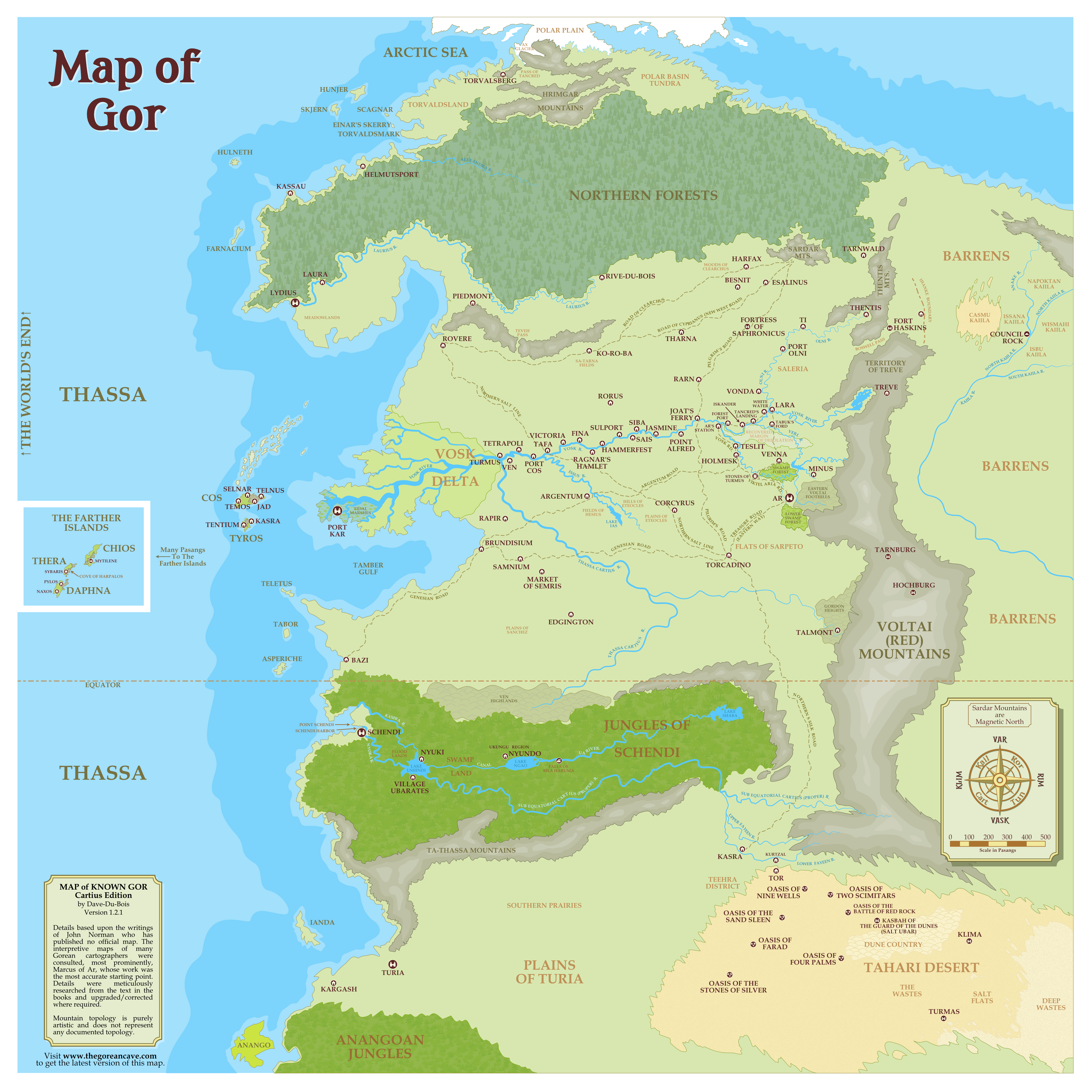
×
(the research of Dave-Du-Bois in his own words) 01- Tarnsmen of GorThe pasang is a measure of distance on Gor, equivalent approximately to .7 of a mile (1.12 Km)Cartius R., Equatorial Lakes13- Explorers of GorCH001-"Tell me what you know of the Cartius,"...It flows west by northwest, entering the rain forests and emptying into Lake Ushindi, which lake is drained by the Kamba and the Nyoka rivers. The Kamba flows directly into Thassa. The Nyoka flows into Schendi harbor, which is the harbor of the port of Schendi, and moves thence to Thassa."It was, at one time, conjectured," said Samos, "that the Cartius proper was a tributary of the Vosk." "I had been taught that," I said. "We now know that the Thassa Cartius and the subequatorial Cartius are not the same river." "It had been thought, and shown on many maps," I said, "that the subequatorial Cartius not only flowed into Lake Ushindi, but emerged northward, traversing the sloping western flatlands to join the Vosk at Turmus." Turmus was the last major river port on the Vosk before the almost impassable marshes of the delta. "Calculations performed by the black geographer, Ramani, of the island of Anango, suggested that given the elevations involved the two rivers could not be the same. His pupil, Shaba, was the first civilized man to circumnavigate Lake Ushindi. He discovered that the Cartius, as was known, enters Lake Ushindi, but that only two rivers flow out of Ushindi, the Kamba and Nyoka. The actual source of the tributary to the Vosk, now called the Thassa Cartius, as you know, was found five years later by the explorer, Ramus of Tabor, who, with a small expedition, over a period of nine months, fought and bartered his way through the river tribes, beyond the six cataracts, to the Ven highlands. The Thassa Cartius, with its own tributaries, drains the highlands and the descending plains." I shrugged. Much of Gor was terra incognita. Few knew well the lands on the east of the Voltai and Thentis ranges, for example, or what lay west of the farther islands, near Cos and Tyros. It was more irritating, of course, to realize that even considerable areas of territory above Schendi, south of the Vosk, and west of Ar, were unknown. "There was good reason to speculate that the Cartius entered the Vosk, by way of Lake Ushindi," I said. "Even the bargemen of the Cartius proper, the subequatorial Cartius, and those of the Thassa Cartius, far to the north, thought the rivers to be but one waterway." The rain forests closed the Cartius proper for most civilized persons from the south," I said, "and what trading took place tended to be confined to the ubarates of the southern shore of Lake Ushindi. It was convenient then, for trading purposes, to make use of either the Kamba or the Nyoka to reach Thassa." "That precluded the need to find a northwest passage from Ushindi," said Samos. "Particularly since it was known of the hostility of the river tribes on what is now called the Thassa Cartius." "Yes," said Samos. "But surely, before the expedition of Shaba," I said, "others must have searched for the exit of the Cartius from Ushindi." "It seems likely they were slain by the tribes of the northern shores of Ushindi," said Samos. "[Shaba] was interested in finding the northwest passage from Ushindi," "But Shaba 's work," I said, "as I understand it demonstrated that no such passage exists." To the west of Lake Ushindi," I said, "there are floodlands, marshes and bogs, through which a considerable amount of water drains into the lake. With considerable hardship, ... thrust through the marshes eastward, after two months, Shaba reached the western shore of what we now know as Lake Ngao." "It is fully as large as Lake Ushindi, if not larger," I said, "the second of the great equatorial lakes." Shaba then continued the circumnavigation of Lake Ushindi," said Samos. "He charted accurately, for the first time, the entry of the Cartius proper, the subequatorial Cartius, into Ushindi. He then continued west until he reached the six ubarates and the heartland of Bila Huruma. discovered that Lake Ngao was fed, incredibly enough, by only one major river, as its eastern extremity, a river vast enough to challenge even the Vosk in its breadth and might, a river which he called the Ua. [Lake Ngao, east] Pursued the [Ua] river for only a hundred pasangs," I said, "when they were turned back by some falls and cataracts." "The falls and cataracts of Bila Huruma, as he named them. intending to join the Ushindi and Ngao with a canal, cut through the marshes, which, then, might be drained Such a canal would be an inestimable commercial and military achievement. The Ua, holding the secret of the interior, flows into the Ngao, which, by a canal, would be joined with Ushindi. Into Ushindi flows the Cartius proper, the subequatorial Cartius. Out of Ushindi flow the Kamba and the Nyoka, and those flow to Thassa. CH060- Lake Ngao, which was discovered by Shaba, and named by him, was named for a shield, because of its long, oval shape. CH016- attempt to join Lakes Ushindi and Ngao, separated by more than four hundred pasangs, by a great canal, a canal that would, via Lake Ushindi and the Nyoka and Kamba rivers, then link the mysterious Ua river, it flowing into Lake Ngao, to gleaming Thassa, the sea, a linkage that would, given the Ua, open up to the civilized world the riches of the interior, riches that must then pass through the ubarate of Bila Huruma. Waters from the overflow of Lake Ngao entered the great marsh between Ngao and Ushindi, and, thence, made their ways to Ushindi, which, by means of the Kamba and Nyoka, drained to gleaming Thassa, the sea. The intent of the engineers of Bila Huruma was to set in place two parallel walls, low walls, some five or six feet high, placed about two hundred yards apart. The area between these walls, the marsh waters diverted on either side, was then to be drained and readied for the digging of the main channel... In the event that the central channel, when completed, would not prove sufficient to handle the overflow of Ngao, as seemed likely, conducting it geometrically to Ushindi, side channels were contemplated. The eventual intent of Bila Huruma was not only to open the rain forests of the deep interior, and whatever might lie within the system of the Ua and her tributaries, to commercial exploitation and military expansion, but to drain the marshes between the two mighty lakes, Ushindi and Ngao, that that land, then reclaimed, thousands of square pasangs. CH057- When Lakes Ushindi and Ngao had been joined by the canal a continuous waterway would be opened between Thassa and the Ua. One might then, via either the Kamba or the Nyoka, attain Lake Ushindi. One might then follow the canal from Ushindi to Ngao. From Ngao one could enter upon the Ua. One could then, for thousands of pasangs, follow the Ua until one reached its terminus in Lake Shaba. And Lake Shaba itself was fed by numerous smaller streams and rivers, each giving promise, like the tributaries of the Ua itself, to the latency of new countries. Kasra - Two Settlements with the Same Name06- Raiders of GorCH013- Kasra is the capitol of Tyros; its only other major city is Tentium.10- Tribesman of GorCH002- I had arrived in Tor four days ago, after first taking tarn to Kasra. From Kasra I had taken a dhow upriver on the Lower Fayeen, until I reached the village of Kurtzal, which lies north, overland, from Tor. Goods which are to be transported from Tor to Kasra sometimes are first taken overland to Kurtzal, and thence west on the river. Kurtzal is little more than a loading and shipping point.Tahari Desert10- Tribesman of GorCH001- Tahari Desert - It was roughly in the shape of a gigantic, lengthy trapezoid, with eastward leaning sides. At its northwestern corner lay Tor, West of Tor, on the Lower Fayeen, a sluggish, meandering tributary, like the Upper Fayeen, to the Cartius, lay the river Port of Kasra.The area, in extent, east of Tor, was hundreds of pasangs in depth, and perhaps thousands in length. The Gorean expression for this area simply means the Wastes, or the Emptiness. It is a vast area, and generally rocky, and hilly, save in the dune country. It is almost constantly windblown and almost waterless. In areas it has been centuries between rains. Its oases are fed from underground rivers flowing southeastward from the Voltai slopes. CH002- I had arrived in Tor four days ago, after first taking tarn to Kasra. From Kasra I had taken a dhow upriver on the Lower Fayeen, until I reached the village of Kurtzal, which lies north, overland, from Tor. Goods which are to be transported from Tor to Kasra sometimes are first taken overland to Kurtzal, and thence west on the river. Kurtzal is little more than a loading and shipping point. CH002- Tor, lying at the northwest corner of the Tahari, is the principal supplying point for the scattered oasis communities of that dry vastness CH007- Other than the well at Klima, there is no other water within a thousand pasangs. (MENTIONED 3 TIMES) CH008- Indeed, it lay in a direction away from Nine Wells, which was the largest, nearest oasis where soldiers might be found. CH010- Turian silk first began to be imported in bulk to the Tahari communities, and northward to Tor and Kasra, thence to Ar, and points north and west. CH010- Two Scimitars is an out-of-the-way oasis CH010- word that Aretai tribesmen had destroyed, or attempted to destroy, a well at Two Scimitars would spread like fire across the desert, inflaming and outraging men from Tor to the Turian outpost merchant fort, and trading station, of Turmas. CH010- Six days ago," said the merchant, "soldiers, Aretai, from Nine Wells raided the Oasis of the Sand Sleen. CH010- If the soldiers of Nine Wells were at their oasis six days ago," said I, "they were not, too, at the oasis of the Sand Sleen. CH011- for the oasis of the Battle of Red Rock was the last of the major oases of the Tahari for more than two thousand pasangs eastward; it lay, in effect, on the borders of the dreaded dune country; there are oases in the dune country but they are small and infrequent, and often lie more than two hundred pasangs apart; in the sands they are not always easy to find: among the dunes one can, unknowingly, pass within ten pasangs of an oasis, missing it entirely. Little but salt caravans ply the dune country. Caravans with goods tend to travel the western, or distant eastern edge of the Tahari; CH011- caravans do, it might be mentioned, occasionally travel from Tor or Kasra to Turmas, a Turian outpost and kasbah, in the southeastern edge of the Tahari, but even these commonly avoid the dune country, either moving south, then east, or east, then south, skirting the sands. Few men, without good reason, enter the dune country. CH013- I had heard of the Salt Ubar, or the Guard of the Dunes. The location of his kasbah is secret. CH015- We knew, generally, Red Rock, the kasbah of the Salt Ubar and such, lay northwest of Klima, CH019- The march of Hassan had as its object not Red Rock, northwest of Klima, but Four Palms, a Kavar outpost known to him, which lay far to the south of Red Rock. Unfortunately Four Palms was farther from Klima than Red Rock. On the other hand, his decision seemed to me a sound one. Red Rock was a Tashid oasis under the hegemony of the Aretai, enemies of the Kavars. Furthermore, between Klima and Red Rock lay the regions patrolled by the men of Abdul, the Salt Ubar, who had been known to me as Ibn Saran. Beyond this, though Four Palms lay farther from Klima than Red Rock, its route, it seemed, would bring one sooner out of the dune country than the route to Red Rock, and into the typical Tahari terrain of rock and scrub, where some game might be found, occasional water and possible nomadic groups not disposed to hostility toward Kavars. All things considered, the decision to attempt to reach Four Palms seemed the most rational decision in the circumstances. CH024- from the kasbah of the Salt Ubar... CH026- The march would proceed to Red Rock, thence to Two Scimitars, thence to Nine Wells, thence, by a major caravan route, to Tor. 19- Kajira of Gor CH029- Some of his salt was said to come even from Klima, somewhere deep within the Tahari itself. The river port of Kasra, on the Lower Fayeen. Kasra lies west of Tor, which lies at the northwestern edge of the Tahari, the great desert, the Wastes. Genesian21- Mercenaries of GorCH009- Torcadino, on the flats of Serpeto, is a crossroads city. It is located at the intersection of various routes, the Genesian, connecting Brundisium and other coastal cities with the south, the Northern Salt Line and the Northern Silk Road, leading respectively west and north from the east and south, the Pilgrims' Road, leading to the Sardar, and the Eastern Way, sometimes called the Treasure Road, which links the western cities with Ar. Supposedly Torcadino, with its strategic location, was an ally of Ar.after delivering his goods in Torcadino, was to return northward on the Genesian to Brundisium, where he was scheduled to pick up a new cargo. CH015- Recently, on the Genesian Road, north of Torcadino, there was an attack on a portion of the Cosian supply trains, a massacre. South East Voltai Mts.21- Mercenaries of GorCH003- Dietrich of Tarnburg, of the high city of Tarnburg, some two hundred pasangs to the north and west of Hochburg, both substantially mountain fortresses, both in the more southern and civilized ranges of the Voltai, was well-known to the warriors of Gor. His name was almost a legend. It was he who had won the day on the fields of both Piedmont and Cardonicus, who had led the Forty Days' March, relieving the siege of Talmont, who had effected the crossing of the Issus in 10,122 C.A., in the night evacuation of Keibel Hill, when I had been in Torvaldsland, and who had been the victor in the battles of Rovere, Kargash, Edgington, Teveh Pass, Gordon Heights, and the Plains of Sanchez. His campaigns were studied in all the war schools of the high cities. I knew him from scrolls I had studied years ago in Ko-ro-ba, and from volumes in my library in Port Kar, such as the commentaries of Minicius and the anonymous analyses of "The Diaries," sometimes attributed to the military historian, Carl Commenius, of Argentum, rumored to have once been a mercenary himself.Kaiila Rivers18- Blood Brothers of GorCH002- The Isanna was the Little-Knife Band of the Kaiila. They came from the countries around Council Rock, north of the northern fork of the Kaiila River and west of the Snake, a tributary to the Northern Kaiila.First, understand that there exists the Kaiila River, flowing generally in a southwestward direction. At a given point, high in the territory of the Kaiila tribe, it branches into two rivers, which are normally spoken of as the Northern Kaiila and the Southern Kaiila. The Snake, flowing in an almost southern direction, is a tributary to the Northern Kaiila. The land of the Napoktan, or Bracelets band of the Kaiila, is east of the Snake, and north of the Northern Kaiila, and the Kaiila proper. The Wismahi, or Arrowhead band of the Kaiila, holds the more northern lands in and below, to some extent, the fork of the Kaiila. The Isbu's lands are the more southern lands between the Northern and Southern branches of the Kaiila. The lands of the Casmu, or Sand band of the Kaiila, lie to the west of the Isanna, and to the north and west of the Isbu, above the descending northern branch of the Northern Kaiila. CH012- This was around Council Rock, north of the northern fork of the Kaiila River and west of the Snake River. CH018- "Napoktan... The Bracelets band," Their territory lies roughly northwest of the Kaiila River, north of the northern fork of the Kaiila River, and east of the Snake River. Napoktan warriors commonly wear two copper bracelets on the left wrist. CH034- Now, deep within the Barrens, north of the Northern Kaiila River, in the country of the Casmu Kaiila, I looked upon the shield itself. 17- Savages of Gor CH003- Kailiauk is the easternmost town at the foot of the Thentis mountains. It lies almost at the edge of the Ihanke, or Boundary. From its outskirts one can see the markers, the feathers on their tall wands, which mark the beginning of the country of the red savages. Saleria Region14- Fighting Slave of GorWe left our house in Vonda a month ago, for my villa." The villa of the Lady Florence of Vonda lay some forty pasangs south and west of Vonda. Vonda was one of the four cities of the Salerian Confederation. The other cities of this confederation were Ti, Port Olni and Lara. All four of these cities lie on the Olni River, which is a tributary to the Vosk. Ti is farthest from the confluence of the Olni and Vosk; downriver from Ti is Port Olni; these were the first two cities to form a league, originally intended for the control of river pirates and the protection of inland shipping; later, downriver from Port Olni, Vonda, and Lara, lying at the junction of the Olni and Vosk, joined the league. The Olni, for practical purposes, has been freed of river pirates. The oaths of the league, and the primitive articles pertaining to its first governance, were sworn, and signed, in the meadow of Salerius, which lies on the northern bank of the Olni between Port Olni and Vonda. It is from that fact that the confederation is known as the Salerian Confederation. The principal city, because the largest and most populous, of the confederation is Ti... The Salerian Confederation, incidentally, is also sometimes known as the Four Cities of Saleria. The expression `Saleria', doubtless owing its origin to the meadow of Salerius, is used broadly, incidentally, to refer to the fertile basin territories both north and south of the Olni, the lands over which the confederation professes to maintain a hegemony. The meadow of Salerius, thus, lies on the northern bank of the Olni, between Port Olni and Vonda; the area called Saleria, on the other hand, is, in effect, the lands controlled by the confederation. Ti, Port Olni and Vonda lie on the northern bank of the Olni; Lara lies between the Olni and the Vosk, at their confluence. It is regarded as being of great strategic importance. It could, if it wished, prevent Olni shipping from reaching the markets of the Vosk towns, and, similarly, if it wished, prevent shipping from these same towns from reaching the Olni markets. Overland shipping in this area, as is generally the case on Gor, is time consuming and costly; also, it is often dangerous. It is interesting to note that the control of piracy on the Olni was largely a function of the incorporation of Lara in the confederation. This made it difficult for the pirate fleets, following their raids, to descend the Olni and escape into the Vosk.Stones of Turmus, Verl, Vosk, Tabuk's Ford11- Slave Girl of GorCH006- He was caste leader in Tabuk's Ford. Tabuk's Ford was a large village, containing some forty families; it was ringed with a palisade, and stood like a hub in the midst of its fields, long, narrow, widening strips, which radiated from it like the spokes in a wheel. Thurnus tilled four of these strips. Tabuk's Ford receives its name from the fact that field Tabuk were once accustomed, in their annual migrations, to ford the Verl tributary of the Vosk in its vicinity. The Verl flows northwestward into the Vosk. We had crossed the Vosk, on barges, two weeks ago. The field Tabuk now make their crossing some twenty pasangs northwest of Tabuk's Ford, but the village, founded in the area of the original crossing keeps the first name of the locale. Tabuk's Ford is a rich village, but it is best known not for its agricultural bounty, a function of its dark, fertile fields in the southern basin of the Verl, but for its sleen breeding. Thurnus, of the Peasants, of Tabuk's Ford, was one of the best known of the sleen breeders of Gor.The village of Tabuk's Ford lay some four hundred pasangs generally north and slightly west. The Vosk road was the road used many years ago by the horde of Pa-Kur, in its approach to the city of Ar. We had traveled the Vosk road after crossing the Vosk on barges. It is wide, and built like a great wall, sunk in the earth. It is marked with pasang stones CH007- The great margin of desolation which once flanked Ar on the north, just south of the Vosk, has not been maintained. It was a long wall of wilderness, an empty, unpopulated, desertlike area without water and beneficient vegetation a thousand pasangs deep. Wells were poisoned and fields burned and salted to prevent the approach of armies from the north. Now, however, in the last years, it has become green. New wells have been dug, peasants have moved into it. the peasant village of Tabuk's Ford, some four hundred pasangs to the north, and slightly to the west of Ar, some twenty pasangs off the Vosk road to the west. She was a girl of peasant stock, who had been, two years ago, stolen by slavers from a village hundreds of pasangs to the west. Thurnus had purchased her in Ar and brought her on a rope behind his wagon to Tabuk's Ford. CH009- through the gate and out onto the dusty road leading from Tabuk's Ford. CH010- We had visited various villages, but, on the whole, we had made our way along the road to Ar. The great road to Ar is marked with pasang stones. We had followed the road to within two hundred pasangs of Ar. Then we had left it, and, for two days, followed a side road. ...looming walls of the merchant keep, Stones of Turmus, a Turian outpost, licensed for the storage of goods within the realm of Ar. Such outposts are not uncommon on Gor. They are useful in maintaining the security of trade. Their function is not military but commercial. Turia is one of the great trading centers of Gor. It lies far to the south, in the middle latitudes of her southern hemisphere. We soon took the road to Stones of Turmus. In an Ahn we had come to the great gate. CH011- You are slave now within the Keep of Stones of Turmus. This is a merchant keep, under the banner and shield of Turia." That the keep was under the banner of Turia designated it as a Turian keep, distinguishing it in this sense not only from keeps maintained by other cities but more importantly from the "free keeps" maintained by the merchant caste in its own right, keeps without specific municipal affiliations. Similarly, the merchant caste, which is international, so to speak, in its organization, arranges and conducts the four great fairs which occur annually in the vicinity of the Sardar mountains. The merchant caste, too, maintains certain free ports on certain islands and on the coasts of Thassa, such as Teletus and Bazi... That the keep was also under the shield of Turia meant that it was defended by Turians, that its garrison was Turian. Sometimes a keep will fly a given banner but its garrison will be furnished by the city within whose territory it lies. It is not unknown for a keep to fly the banner of one city and stand behind the shield of another. Both banner and shield of Stones of Turmus, however, were Turian. CH014- I looked out, over the bridge, to the towers and cylinders beyond, and to the sunset over the walls of Ar. The Islands06- Raider of GorCH010- My four commercial voyages had been among the exchange islands, or free islands, in Thassa, administered as free ports by members of the Merchants. There were several such islands. Three, which I encountered frequently in my voyages, were Teletus, and, south of it, Tabor, named for the drum, which it resembles, and to the north, among the northern islands, Scagnar. Others were Farnacium, Hulneth and Asperiche. I did not go as far south as Anango or Ianda, or as far north as Hunjer or Skjern, west of Torvaldsland. There islands, with occasional free ports on the coast, north and south of the Gorean equator, such as Lydius and Helmutsport, and Schendi and Bazi, make possible the commerce between Cos and Tyros, and the mainland, and its cities, such as Ko-ro-ba, Thentis, Tor, Ar, Turia, and many others.10- Tribesmen of GorCH001- I regarded the vast map on the floor of the chamber. I could see, high on the map, Ax Glacier, Torvaldsland, and Hunjer and Skjern, and Helmutsport, and lower, Kassau and the great green forests, and the river Laurius, and Laura and Lydius, and lower, the islands, prominent among them Cos and Tyros; I saw the delta of Vosk, and Port Kar, and, inland, Ko-ro-ba, the Towers of the Morning, and Thentis, in the mountains of Thentis, famed for her tarn flocks; and, to the south, among many other cities, Tharna, of the vast silver mines; I saw the Voltai Range, and Glorious Ar, and the Cartius, and, far to the south, Turia, and near the shore of Thassa, the islands of Anango and Ianda, and on the coast, the free ports of Schendi and Bazi. There were, on the map, hundreds of cities, and promontories and peninsulas, and rivers and inland lakes and seas.29- Swordsmen of GorCH002- The last thing Port Kar, or these other powers, needs is a land war, which would have to be primarily conducted by mercenaries. Cos is already overextended in this manner in the south, at Ar. Indeed, there now tends to be little interaction, at least ashore, amongst these powers. Much contest, however, is done for the mastery of certain sea lanes, particularly toward the south, and towards Tabor and Asperiche, and even as far south as Bazi, Anango, and Schendi.20- Players of GorCH006- Anango, like Asperiche, is an exchange, or free, island in Thassa, administered by members of the caste of merchants. It is, however, unlike Asperiche, very far away. It is far south of the equator, so far south as to almost beyond the ken of most Goreans, except as a place both remote and exotic. The jungles of the Anangoan interior serve as the setting for various fanciful tales, having to do with strange races, mysterious plants, and fabulous animals. The "magicians of Anango," for what it is worth, seem to be well known everywhere on Gor except in Anango. In Anango itself it seems folks have never heard of them.24- Vagabonds of GorCH049- "Are you from Teletus, Asperiche, Tabor?""No, Master," she said. "I am not from Teletus, or Asperiche, or Tabor." "Where are you from?" he snarled. She whimpered, his grip was so tight on her. "Cos," she said. "From Telnus." "Impossible!" he said. "We obtained you here, near Brundisium! Brundisium is an ally of Cos. Cosian women would not be sold here!" 12- Beasts of GorCH002- He conducted me to a place in the hail, where he pointed down to that portion of the intricate map mosaic which lay there."Cos and Tyros," I said. He pointed beyond them. For most practical purposes, except for a few small, close islands, of little or no importance, the mosaic ended there. No one knew what lay beyond Cos and Tyros to the west, once the small islands were passed. "You should have your mind not on Kaissa," said Samos, "my dear Captain, but on the world's end." He pointed to a place on the floor. It contained only small, smooth white tiles. "Perhaps the world's end," I said, "is on the other side of the wall." We did not know where it might be, in the scale of the map mosaic. "Perhaps," laughed Samos. "Perhaps." He glanced about at the mosaic. For an instant his eye stopped, near its top. "What is it?" I asked. ... "Two items of information we have received seem to us peculiar. We have received them at different times. They are in their nature, unrelated. Yet each is provocative." "What are they?" I asked. "See," said Samos, crouching down, holding the lamp about a foot above the floor, "here is Kassau, and the Skerry of Vars."... "And Torvaldsland, northwards," he said, "and Ax Glacier." "Yes," I said. "Have you heard," he asked, "of the herd of Tancred?" "No," I said. "It is a herd of northern tabuk," said Samos, "a gigantic herd, one of several. The herd of Tancred winters in the rims of the northern forests south and east of Torvaldsland. In the spring, short-haired and hungry, they emerge from the forests hind migrate northward." He indicated the map. "They follow this route," he said, "emerging from the forest here, skirting Torvaldsland here, to the east, and then moving west above Torvaldsland, to the sea. They follow the shore of Thassa north, cross Ax Glacier here, like dark clouds on the ice, then continue to follow the shore north here, until they then turn eastward into the tundra of the polar basin, for their summer grazing. With the coming of winter, long-haired and fat, they return by the same route to the forests. This migration, like others of its kind, occurs annually." 35-Quarry of GorCH029- boarded a game ship for the Skerry of Lars, not really a skerry, but a small island five pasangs out in the Tamber Gulf, five pasangs beyond the laws of Port Kar.09- Marauders of GorCH020- The Skerry of Vars is roughly a hundred foot, Gorean, square. It is rough, but, on the whole, flat. It rises some fifteen to twenty feet from the water. It is grayish rock, bleak, upthrust, igneous, forbidding.The Farther Islands30- Avengers of GorCH001- We were on Chios, the closest of the three 'Farther Islands', Chios, Thera, and Daphna, those islands beyond Tyros and Cos, once taken as marking the end of a world, beyond which lay only terror and mystery, and the devouring, waiting, stirring vastness of turbulent Thassa,"A rumor, aflight in a tavern in Sybaris, high town of Thera," I said, "overheard nine days ago." Nicosia was a shoreline hamlet of south Chios, within the hegemony of Cos, as are Thera and Daphna CH003- From the Cove of Harpalos on Thera, I might take the Tesephone to the harbor of Sybaris. To be sure, the influence of Cos was far more pervasive and powerful in the larger towns and ports, such as Sybaris on Thera, Mytilene on Chios, and Pylos and Naxos on Daphna. Indeed, in such towns, high administrative, military, and naval offices were largely staffed by Cosians. Nicosia, being on Chios and Sybaris on Thera, it was like Sybaris was a world away from Nicosia. Sybaris has rich fields inland," I said, "and a fine, busy harbor. In Sybaris there is much luxury and wealth, broad, prosperous streets, many of which are lit at night, colorful bazaars and variegated, well-stocked markets, ample inns, and hundreds of shops, restaurants, and taverns. The city is brighter and more alive at night than in the day. Even at the First Ahn, taverns thrive, and, on the streets, crowds bustle about, and gamblers gather on corners, breathlessly attentive to the rattle of cast stones, while flautists play and silken slaves dance on their leashes, coin pans at hand." "We are days from Sybaris," said Aktis. CH008- high and inconspicuous amongst the rocks and ledges below which lay the sheltering Cove of Harpalos, with its small cluster of huts and sheds... The Cove of Harpalos was not heavily trafficked, but it was, in effect, the port by means of which several inland villages, bartering the produce of their gardens and orchards, could reach the sea. Cove of Harpalos was not a hub of trade nor a metropolis, but its existence was not negligible; it was not likely to be ignored or overlooked. It had been included in the map table in the receiving chamber of Archelaos, governor of Thera. "I do not think so," I said. "I think the fleet, over the past few days, has been perusing nearby settlements, for it would have been supposed we would not be far from Sybaris. The Cove of Harpalos would be on any list of nearby suspect ports." CH009- ...if we put aside Thera, how many plausible villages are left, on Chios and Daphna?" "Something like a hundred and twenty," I said By my count, given the map, and limiting myself to villages within ten pasangs of the coast," I said, "sixty-three." "It is more hopeless than ever," groaned Thurnock. I was more troubled by the fact that on the voyage from the Cove of Harpalos to the beach of Nicosia we had not encountered the small, dark island originally encountered on the voyage from Nicosia to the Cove of Harpalos. Similarly, on the voyage from Nicosia to Sybaris, after painting the Tesephone white and yellow, colors of the Merchants, so that it would stand out, and not be difficult to detect amongst the billows of Thassa, we had again failed to encounter the small, dark island. You obtained charts at the Cove of Harpalos," had said Clitus. "Is it not on the charts?" "No," I said. "It is not charted," had said Clitus. "It is too small. Many tiny islands fail to appear on the charts." CH012- Though there are some silver mines on Thera, presumably contributing to the wealth of Sybaris, the Farther Islands were not noted for their mineral resources. Certainly they were not noted for their streams glittering with nuggets or mountains and caves bright with veins of gold. On the false map, drawn with care, I had located the mythical Village of Flowing Gold twenty pasangs inland. CH014- We were a day from Daphna, following our destruction of the raider fleet. I had set our course for the Cove of Harpalos, I supposed that the search for us... was unlikely to be resumed, at least at that place, no more than at dozens of other inlets and coves which had been examined in vain. "...encountered on our course from Chios to the Cove of Harpalos." We could see some brush, and huts, some drying nets, and some small fishing boats, these beached on the grayish, flattish, featureless surface. "What they take to be the nearest village," I said. "Captain?" asked Clitus. "The nearest village," I said, "is some three hundred pasangs away and I neglected to include it on the map. I did include some closer villages on the map, but they exist only on the map." CH015- In my tent, high amidst the crags of the Cove of Harpalos, I angrily thrust aside the reports of several selected men, chosen from the crews of the Dorna and Tesephone, these acting as informants, frequenting the bazaars, the alleys and streets, the taverns and inns, the wharves and waterfronts, of Sybaris. Even if the vulos released at the time of our attack, messageless or not, returned to some cot in Sybaris, it would have taken days for ships to reach Daphna... Have you heard of the Fair of the Farther Islands?" I asked. "No," said Tab. "This year," I said, "it is being held at Mytilene on Chios." "Nicosia was on Chios," said Tab. CH023- Before the Fair of the Farther Islands," said Xanthos, "the village of Seleukos was amongst the richest villages on Thera." "But not now?" said Thurnock. "It was burned and looted," CH030- We, on the other hand, had brought two hundred and fifty men from Port Kar, most of whom were with us, saving some posted as spies in Sybaris; some left at the ruins of Nicosia... After we had left the Cove of Harpalos, we had visited the ruins of the village of Seleukos... CH033- Eiron, of the Fields of Chios,... CH035- The towns despise the fields and look down upon them, while the fields scorn the towns and think little of them. They do not share Home Stones or interests." CH041- ...first, their terror of the supposed Bosk of Port Kar and their awareness of the merciless depredations inflicted in his name on several villages, such as Nicosia on Chios itself, and, second, the accounts of the harbor refugees of the unconstrained savagery and blood-thirstiness of the pillagers in the harbor. The heads of the council's small negotiating party were catapulted over the wall of Mytilene. It was toward noon, the tenth Ahn, on the twentieth day of the siege, a bright, windy day, that Thrasymedes joined Thurnock, Clitus, and myself on a ragged, uneven portion of rebuilt wall, now, at this point, only some fifteen feet in height. Our footing was on a broad, wooden scaffolding, formed from timbers of demolished houses. CH044- The walls of Mytilene, a town on Chios, were far from the high, thick walls of an Ar or Turia, but the dangers and principles of this form of warfare were quite similar. CH051- There is the coast of Chios," said Thurnock, pointing forward, toward the thin brown line, half visible over the water. CH053- Do not fear the Brigand Island," said Sakim. "It was wounded, torn, and burned. It was abandoned near Chios. CH054- "Shall we maintain our present course, to the Cove of Harpalos?" asked Sakim. "No," I said. "Set our course for Sybaris, straight for Sybaris." CH058- "I am curious, Captain," said Sakim, "why you have persisted in holding our course for Sybaris and not the Cove of Harpalos, which is closer." CH059- ...noble Nicomachos, ...land action on Chios near Mytilene, ...the Theran fleet cut the corsair fleet off from its base in Sybaris, and the width of its line prevented an escape to the side. The corsair fleet then, fleeing toward Chios, had either been caught near Chios or had tried to land on Chios and, encountering the hostile, armed Peasantry on the beaches, fresh from Mytilene and its vicinity, had put once more to sea, where it eventually fell to the pursuing Theran fleet, say, some fifty pasangs off the coast of Chios. ..."It seems they succeeded in deceiving Nicomachos, perhaps on a beach of Chios... CH063- After leaving the Cove of Harpalos, Tab was to lay a course for Chios and disembark Aktis and his slave on the coast near the ashes of Nicosia. |       | |||||||||||||||||||||||||||||||||||||||||
